
-
Welcome to H4O! For a reduced ad experience, please login or register with the forum.
You are using an out of date browser. It may not display this or other websites correctly.
You should upgrade or use an alternative browser.
You should upgrade or use an alternative browser.
H4O SoCal Events - Mark Your Calendar
- Thread starter cbetts
- Start date
- Messages
- 10,401
- Location
- Central Texas
Hey Mike, welcome back!
Sierra H3
Well-Known Member
- Messages
- 150
- Location
- Central Sierras
Back on the Road
It must be great to get the truck back on the road! :thumbs: Quite a few years ago, I totaled a truck on the freeway. Decided not to rebuild, but it was a sad decision. I missed having that rig for a number of years.
It must be great to get the truck back on the road! :thumbs: Quite a few years ago, I totaled a truck on the freeway. Decided not to rebuild, but it was a sad decision. I missed having that rig for a number of years.
cbetts
NERD!!!
- Messages
- 3,182
- Location
- Rancho Palos Verdes, CA
- Messages
- 10,401
- Location
- Central Texas
Cool. Looking forward to it.
Anza Borrego 12/10/11?
What are the plans for the Anza Borrego trip?
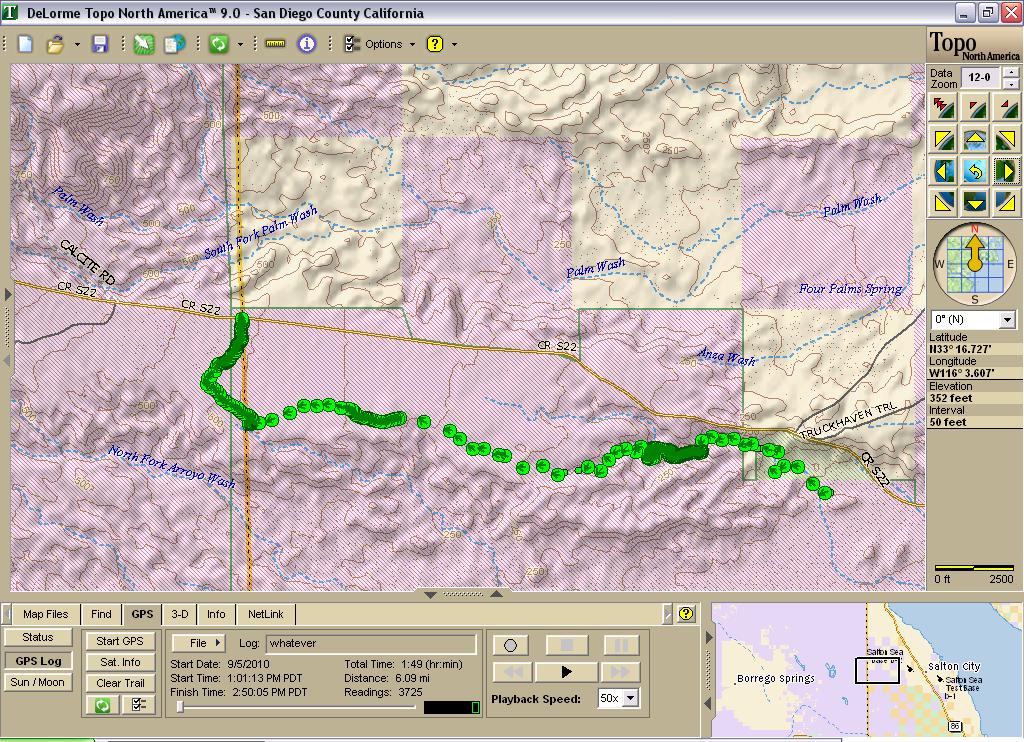
The trail I was talking about at the M&G is the Calcite Mine Trail. In Backcountry Adventures (South Coast #29 page 381-382) they list it a 1.9 miles and 45 minutes one way but since it is a dead end trail it is 3.6 miles and 1.5 hours. They give the trail a difficulty rating 7 :whaa: and scenic rating 9. To get to it you take S22 Borrego-Salton Seaway 18.5 miles from Borrego Springs. Here is a dirtopia page on the trail :link:. Description; "Although short, Calcite Mine Trail is a challenging trail for high-clearance 4WD vehicles, ... Sections of this wartime road are beginning to wash away, leaving a narrow path for vehicles around the natural erosion. The difficult section begins 0.9 miles from the start. Deep, uneven sections need to be straddled, and careful wheel placement is necessary to avoid dropping into them or catching your undercarriage on rocks. The clay surface is very greasy when wet, and the trail should be avoided after rain. The trail becomes more difficult after crossing palm wash; there are large embedded boulders to climb. The trail ends at the Calcite Mine area, on a flat turn-around that offers a wonderful view towards Mexico. The large, deep mine trenches still contain some beautiful calcite crystals, which can be admired in place. Collecting is prohibited within the state park."
Right at the end of the Calcite Mine Trail is Truckhaven Trail (South Coast #26 page 372-375) which is 11.3 miles and takes 1.25 hours. Difficulty rating 5 although the detour around a wash out rates a 7 and it is the only way through. Here is a dirtopia page :link:.
Just a suggestion.
What are the plans for the Anza Borrego trip?
The trail I was talking about at the M&G is the Calcite Mine Trail. In Backcountry Adventures (South Coast #29 page 381-382) they list it a 1.9 miles and 45 minutes one way but since it is a dead end trail it is 3.6 miles and 1.5 hours. They give the trail a difficulty rating 7 :whaa: and scenic rating 9. To get to it you take S22 Borrego-Salton Seaway 18.5 miles from Borrego Springs. Here is a dirtopia page on the trail :link:. Description; "Although short, Calcite Mine Trail is a challenging trail for high-clearance 4WD vehicles, ... Sections of this wartime road are beginning to wash away, leaving a narrow path for vehicles around the natural erosion. The difficult section begins 0.9 miles from the start. Deep, uneven sections need to be straddled, and careful wheel placement is necessary to avoid dropping into them or catching your undercarriage on rocks. The clay surface is very greasy when wet, and the trail should be avoided after rain. The trail becomes more difficult after crossing palm wash; there are large embedded boulders to climb. The trail ends at the Calcite Mine area, on a flat turn-around that offers a wonderful view towards Mexico. The large, deep mine trenches still contain some beautiful calcite crystals, which can be admired in place. Collecting is prohibited within the state park."
Right at the end of the Calcite Mine Trail is Truckhaven Trail (South Coast #26 page 372-375) which is 11.3 miles and takes 1.25 hours. Difficulty rating 5 although the detour around a wash out rates a 7 and it is the only way through. Here is a dirtopia page :link:.
Just a suggestion.
LagunaH1
Well-Known Member
- Messages
- 3,705
- Location
- Lake Forest, CA
Granted it's probably been about a year since I was out by the Calcite mine trail but in my opinion it is far from challenging. It's a fairly short trail so I'd suggest we consider combining it with something else
Kurt
Well-Known Member
- Messages
- 957
- Location
- Orange County, CA
What are the plans for the Anza Borrego trip?
The trail I was talking about at the M&G is the Calcite Mine Trail. In Backcountry Adventures (South Coast #29 page 381-382) they list it a 1.9 miles and 45 minutes one way but since it is a dead end trail it is 3.6 miles and 1.5 hours. They give the trail a difficulty rating 7 :whaa: and scenic rating 9. To get to it you take S22 Borrego-Salton Seaway 18.5 miles from Borrego Springs. Here is a dirtopia page on the trail :link:. Description; "Although short, Calcite Mine Trail is a challenging trail for high-clearance 4WD vehicles, ... Sections of this wartime road are beginning to wash away, leaving a narrow path for vehicles around the natural erosion. The difficult section begins 0.9 miles from the start. Deep, uneven sections need to be straddled, and careful wheel placement is necessary to avoid dropping into them or catching your undercarriage on rocks. The clay surface is very greasy when wet, and the trail should be avoided after rain. The trail becomes more difficult after crossing palm wash; there are large embedded boulders to climb. The trail ends at the Calcite Mine area, on a flat turn-around that offers a wonderful view towards Mexico. The large, deep mine trenches still contain some beautiful calcite crystals, which can be admired in place. Collecting is prohibited within the state park."
Right at the end of the Calcite Mine Trail is Truckhaven Trail (South Coast #26 page 372-375) which is 11.3 miles and takes 1.25 hours. Difficulty rating 5 although the detour around a wash out rates a 7 and it is the only way through. Here is a dirtopia page :link:.
Just a suggestion.
We can probably do Calcite mine combined with Truckhaven since they are in the same area and route.
I did some exploring south of Calcite and Truckhaven last time I was out there [I left the rest area ran west toward Arroyo with mechmike then popped up next to the radio/microwave transmitter on the way out:
SundayTrail by Halfshaft, on Flickr
What I'd like to do is to .. roughly speaking, meet at Christmas Circle, convoy to area A to run trails, take a lunch break, swing south and run group of trails B then cut back to Borrego Springs and the sports bar located there for dinner.
So tentatively speaking, We could run SR22 to Calcite and Truckhaven, have lunch at the campground south of SR22 [which has toilet facilities and tables] then either cut through Salton and powerline road cross the park or take 86 to 78 and go to the Octotilo Wells SRVA area which has some dunes, hill climbs and rolling hills.
Difficulty wise I never bumped into anything that was really difficult out there, theres the trail with heart attack hill but that's narrow and isn't an option for us.
I just got back from Vegas, I'll pour over a few trail maps tonight and post a few options.
I'll be heading up Friday night, staying over at a local motel for Friday and Saturday and heading back Sunday.
The big problem is going to be finding something that ranks as difficult, otherwise this would be an easy to moderate run. Truckhaven has a few optional hard spots...
H3-ING
AdventureTime
- Messages
- 156
- Location
- Newport Heights
http://www.parks.ca.gov/pages/638/files/ABDSPmap.pdf
Anza is really a great sight-seeing, remote camping, hiking, picnic, basic scenic get out on the trail park. Nothing difficult except for a few obstacles here and there.
Trails to consider:
North- Coyote Creek, Calcite, Truckhaven, Font's Point
West- Grapevine, Jasper, Culp, Pinyon
East- Canyon sin Nombre, Diablo drop offs, Fish Creek, Sandstone Canyon, Ocotillo Wells
South- Dos Cabezas, Montero Wash, Goat Canyon Trestle Hike http://www.anzaborrego.net/Travel/A...g-to-Anza-Borrego-s-Goat-Canyon-Trestle-.aspx
Again mostly easy to moderate trails but a great way to spend the day or weekend outdoors.:thumbs:
Last edited:
cbetts
NERD!!!
- Messages
- 3,182
- Location
- Rancho Palos Verdes, CA
We can probably do Calcite mine combined with Truckhaven since they are in the same area and route.
I did some exploring south of Calcite and Truckhaven last time I was out there [I left the rest area ran west toward Arroyo with mechmike then popped up next to the radio/microwave transmitter on the way out:
SundayTrail by Halfshaft, on Flickr
What I'd like to do is to .. roughly speaking, meet at Christmas Circle, convoy to area A to run trails, take a lunch break, swing south and run group of trails B then cut back to Borrego Springs and the sports bar located there for dinner.
So tentatively speaking, We could run SR22 to Calcite and Truckhaven, have lunch at the campground south of SR22 [which has toilet facilities and tables] then either cut through Salton and powerline road cross the park or take 86 to 78 and go to the Octotilo Wells SRVA area which has some dunes, hill climbs and rolling hills.
Difficulty wise I never bumped into anything that was really difficult out there, theres the trail with heart attack hill but that's narrow and isn't an option for us.
I just got back from Vegas, I'll pour over a few trail maps tonight and post a few options.
I'll be heading up Friday night, staying over at a local motel for Friday and Saturday and heading back Sunday.
The big problem is going to be finding something that ranks as difficult, otherwise this would be an easy to moderate run. Truckhaven has a few optional hard spots...
So, is this the final plan? I want to get the official thread started for this trip so people can plan ahead a bit.
Kurt
Well-Known Member
- Messages
- 957
- Location
- Orange County, CA
That's the rough plan.
I know a few folks are only planning making this a day trip, it's too long haul for me to do that, so I'll be there Friday night to Sunday. I know at least one other H1 will stay over night, we may do a night run in an easy area if they have extra lights. I got a few astronomy fans riding with me, since Borrego Springs is a "Dark Skyes" town with minimal light pollution, I'd recommend bringing a pair of binoculars along for stargazing if you are planning to stay overnight.
Since most of the trip will be during the day, I think limiting us to 2 areas would work best. Truckhaven/the mine being one, then we'll pick a second trail to run int he afternoon. There's dozens of places but we have to limit our scope.
Kurt
Well-Known Member
- Messages
- 957
- Location
- Orange County, CA
Do you want me to post up the thread? Or do you guys want to do that? I'll post a long list of trail options but chances are we'll do a loop, swing North from Borrego Springs to Truckhaven and the Mine, have lunch, then either cut through the park down to the southern half of the park for dunes and hill climbs, followed by Dinner in Borrego Springs.
I'll post up maps and details friday night..+
I'll post up maps and details friday night..+
cbetts
NERD!!!
- Messages
- 3,182
- Location
- Rancho Palos Verdes, CA
Do you want me to post up the thread? Or do you guys want to do that? I'll post a long list of trail options but chances are we'll do a loop, swing North from Borrego Springs to Truckhaven and the Mine, have lunch, then either cut through the park down to the southern half of the park for dunes and hill climbs, followed by Dinner in Borrego Springs.
I'll post up maps and details friday night..+
You can post if you want. Just make sure to keep up with the details and confirmation list so we make sure everyone gets there okay.